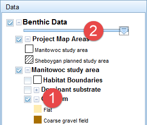
Explore different datasets by clicking on the checkboxes within the data panel on the right. Each
dataset includes a key to explain map symbols. Some keys can be expanded or collapsed by
clicking the + or – box next to the checkbox. (1)
Change the transparency of datasets by dragging the toggle on the slider bar under the Benthic Data,
Additional Data or Additional Imagery layer groups. (2)
 Learn more
 about specific features by clicking the feature(s) of interest on the map. A new window
showing feature attributes will open when a feature is clicked on. The features from each layer that is
turned on will be shown in a separate tab. The features will be highlighted on the map. Click on a specific
row to flash the feature. The window can be moved by clicking on the black header and dragging it to a new
position.
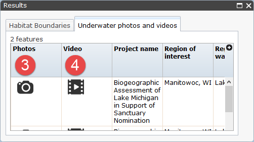
View photos or watch videos by clicking on an underwater photo and video feature and then clicking
the camera icon (3) for photos or the video reel icon (4) for videos. A new window will open with the
selected photo or video.
 Zoom
Zoom into specific areas of the map by scrolling your mouse wheel, double-clicking on the map, or
using the + or – buttons located in the upper left-hand corner of the map.
Pan to view other sections of the map by holding down your left-mouse button and dragging the mouse
across the map.
Search for specific data fields by clicking the Search tab on the right-hand side of your site.
Then choose a layer (e.g. benthic habitat), a data field (e.g. depth), and an operator (e.g. is greater
than) from dropdown menus, and enter a value (e.g. 50). Click Submit. Using these examples, the BIOMapper
will search for and select all benthic habitat features located deeper than 50 feet.
Change the background map by clicking the Change Background Map panel and clicking on the desired
basemap.
 An official website of the United States government.
  Official websites use .gov
 Secure .gov websites use HTTPS